Tres Rios
Introduction
The rapid settlement of Arizona is a relatively new phenomenon beginning in the early 1900s and speeding up exponentially in the years following World War II. Before this time the Salt and Gila Rivers flowed freely through the mountains and valleys of central Arizona. These rivers and their tributaries sculpted a dynamic landscape. Each year spring floods would inundate hundreds of miles of floodplain, creating new arrangements of oxbows and pools as the water receded. These meandering rivers fed a vast system of wetlands dominated by ancient mesquite bosques—a winding oasis of marshland favored by birds, fish, and amphibians.
 Dams built for flood control and water distribution have all but ended the cycle of wetland creation. Like most of Arizona’s rivers, the Gila and Salt are no longer free flowing and are intermittent for long stretches, especially within the state’s largest cities. The restriction of water and the spread of urban development have decimated this habitat. Today it requires a considerable leap to imagine South Phoenix as the verdant wetland it once was.
The same story is evident in the Tres Rios area, a stretch of the Gila River loosely defined by the Salt River confluence to the West and by the Hassayampa and Aqua Fria Rivers to the East. Only patches of wetland remain, constricted to places like the Robbins Butte Wildlife Area south of Buckeye and re-born in constructed wetlands along the Salt and Aqua Fria Rivers.
Human History
Long before Arizona was even a territory, the pre-historic Hohokam thrived in the Arizona desert. By making clever use of these rivers they were able to irrigate thousands of acres of desert, transforming arid valleys into fertile agricultural and economic centers. Like the Hohokam, settlers in the late nineteenth century were primarily agrarian. Unlike the Hohokam, who likely abandoned the area when resources were no longer plentiful, Arizona’s new era of settlement would be seemingly unlimited.The Phoenix area has long benefited from the dams and reservoirs built along the Salt River under the United States Bureau of Reclamation. As one of the original tasks undertaken by Reclamation, the Salt River Project provided unprecedented water resources and flood control for the region. The Central Arizona Project, also built by Reclamation, supplies additional water from the Colorado River. For Maricopa County, the substantial cost of a continuous water supply is wetland habitat. Once mighty rivers are now mostly dry except in areas set aside to receive wastewater or leftover irrigation.
In 1980 Arizona enacted the Groundwater Management Act. This kind of legislation, along with a growing environmental awareness, has led to a greater concern for the environmental impact of water consumption as well as the renewability of water resources. The Tres Rios demonstration wetland, the Urban Rivers Restoration Initiative, and the El Rio Educational Research and Development Project are three examples of city, state, and federal organizations working in cooperation to restore habitat, rejuvenate wildlife, and improve water quality in the Tres Rios area.
Ecological Importance
The mesquite bosques and reedy marshes of the Tres Rios area are of particular importance to birds. Plentiful food and nesting resources attract hundreds of species of breeding birds. Some species, white-winged and mourning doves in particular, arrive in flocks that number in the thousands. These wetlands provide habitat for migrants as well. Robbins Butte Wildlife Area is home to more than 115 species of winter-resident birds and is the center of the National Audubon Society’s annual Gila River Christmas Bird Count. Many raptors, including the white-tailed kite and bald eagle, are included in this list.Wetlands along the Gila River and throughout the Tres Rios area are home to a diverse group of reptiles, a minimum of 19 species, as well as deer, ring-tail cats, and other mammals. The northern leopard frog, western yellow-billed cuckoo, and the Sonoran desert tortoise, are only a few of Tres Rios’ threatened species, listed as Wildlife of Special Concern by the Arizona Game and Fish Department.
Prolific non-natives and water contamination threaten native fish and other wildlife. Pesticides including DDT continue to be found in fish and spiny soft-shell turtles. In many places dense salt-cedar, or tamarisk, thickets crowd out mesquite, cattail, and other forms of native riparian vegetation. Current programs aimed at the rehabilitation of Tres Rios wetland include strategies for the control of this particularly tenacious invader.
Conservation
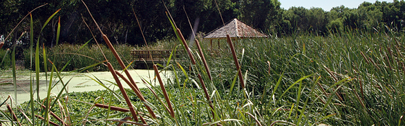
In Phoenix, the U.S. Army Corps of Engineers and the city government are engaging in an ambitious restoration plan to expand the Tres Rios demonstration watershed along a 7-mile stretch of the Salt and Gila Rivers. Originally built by Reclamation, the demonstration watershed provides critical habitat to a plethora of waterfowl and aquatic life. This constructed watershed is used to treat thousands of gallons of wastewater. Lined with towering cottonwoods, seep willows, and dense stands of cattail, the site is as scenic as it is functional. Tres Rios also serves as a laboratory for biologists and hydrologists looking to better understand the interface between urban settlement and native ecosystems.Other plans involve restoring the Gila River’s natural flood control functions. The El Rio Educational Research and Development Project aims to re-establish communities of native wildlife and restore natural flow by replacing large stands of tamarisk with mesquite and other native plants. Ideally, these efforts will not only rejuvenate a diminishing habitat, but reduce widespread flooding and provide recreation opportunities for tourists and nearby residents.
Contributing Writers
Kim Whittley
Photo © City of Phoenix Water Services Department
Links
Visitation
Robbins Butte Wildlife Area
Tres Rios Demonstration Wetlands
History
U.S. Army Corps of Engineers
Central Arizona – Phoenix Long-Term Ecological Research
United States Bureau of Reclamation
Salt River Project
Conservation
Environmental Protection Agency--River Corridor and Wetland Restoration
Environmental Protection Agency—Urban Rivers Restoration Initiative
Flood Control District of Maricopa County
United States Army Corps of Engineers—Urban Rivers Restoration Planning
Bibliography
- Anderies, J.M. 2006. Robustness, institutions, and large-scale change in social-ecological systems: The Hohokam of the Phoenix Basin. Journal of Institutional Economics 2:133-155.
- Briggs, J.M., K.A. Spielmann, H. Schaafsma, K.W. Kintigh, M. Kruse, K. Morehouse and K. Schollmeyer. 2006. Why ecology needs archaeologists and archaeology needs ecologists. Frontiers in Ecology and the Environment 4:180-188.
- Ground water quality in the west Salt River Valley, Arizona, 1996-98—Relations to Hydrogeology, water use, and land use. Water-Resources Investigation Report 01—4126. National Water Quality Assessment Program.
- United States Department of Interior, Bureau of Reclamation. 1972. The Federal Reclamation Program: Its Impacts, Issues and Future Considerations. Denver: Bureau of Reclamation. United States Army Corps of Engineers. 1997. Tres Rios, Arizona Reconnaissance Report, April, U.S. Army Corps of Engineers, Los Angeles District. United States Army Corps of Engineers. 1999. Tres Rios, Arizona Feasibility Study, F4 Documentation, June, DRAFT, U.S. Army Corps of Engineers, Los Angeles District.