
THE BILL WILLIAMS NATIONAL WILDLIFE REFUGE ARIZONA HERITAGE RIVERS SITE
Introduction
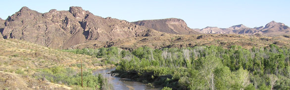
A ribbon of green in an otherwise austere Sonoran Desert landscape, the Bill Williams River supports the largest stand of cottonwood-willow forest remaining along the lower Colorado River. One of three, large natural perennial tributaries entering the Colorado River downstream of Grand Canyon, its unique blend of upland desert, marsh, and riparian habitat supports a diverse assortment of birds, mammals, and reptiles.
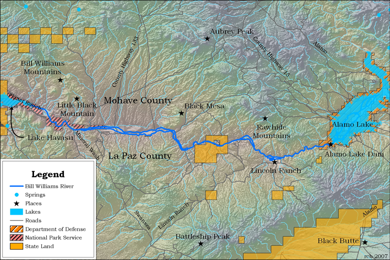
The Bill Williams River originates in west central Arizona some 30 miles east of Kingman. It flows to the southwest into Alamo Lake, formed by Alamo Dam, and then continues west for 42 miles into Lake Havasu, formed by Parker Dam. Prior to the construction of Alamo Dam, the river’s flow was perennial. Today, much of the drainage flows only during rainstorms. Perennial reaches remain only in the headwaters, maintained by spring flow, and a 10-mile stretch below Alamo Dam, maintained by dam releases. Although during times of heavy runoff the releases may reach as much as 7,000 cubic feet per second (cfs), they are generally less than 40 cfs. These water releases are regulated by the U.S. Army Corps of Engineers, in cooperation with the U.S. Fish & Wildlife Service.
Ecological Importance
The marshlands and wetlands along the Bill Williams River—increasingly rare in the desert southwest—are bordered by a riparian zone of cottonwood, willows, and non-native salt cedar, and then by cactus and yucca typical of the Sonoran Desert. This area is recognized for its wildlife diversity that includes over 300 species of birds and a variety of mammals, fish, reptiles, amphibians, and invertebrates.This site has been designated as Critical Habitat for the federally endangered bonytail chub that clings to survival in the waters of the Bill Williams River, along with the endangered razorback sucker. The area also provides important habitat for endangered birds such as the southwestern willow flycatcher, brown pelican, and Yuma clapper rail, as well as the threatened bald eagle and secretive yellow-billed cuckoo, a candidate species.
Human History
The first inhabitants of the lower Colorado River Valley were nomadic hunters and gatherers and are thought to have arrived around 15,000 B.C. By the arrival of the first Europeans, they had developed into several tribes who lived and farmed in the lower Colorado River region. This included the Mohave and Chemhuevi Tribes, who lived in temporary brush and earthen lodges along the Bill Williams River.The first Europeans to travel the Bill Williams corridor were led by Juan de Onate, who traveled from New Mexico to the Gulf of California in 1604. Another party led by Francisco Garces stopped at the confluence in 1775. In 1853, Lieutenant A.W. Whipple surveyed this valley for a railroad west to California. Throughout the 1800s, this river valley was used by many tribes, settlers, merchants, explorers, trappers, and the militia who left no written records. The river was named after mountain man William Shirley “Bill” Williams.
Several towns were established on or near the Bill Williams River during the 1800s including Swansea (~1862), Planet (~1863), and Aubrey (~1866). These provided supplies to miners and early settlers and survived into the 1900s, but now they are all ghost towns. The Esquerra and Koehn Ranches, established along the river in the late 1800s, functioned into the early 1900s.
Conservation
The 6,105-acre Bill Williams River National Wildlife Refuge lies 23 miles south of Lake Havasu City and includes the lower 10 miles of the Bill Williams River. The refuge is managed by the U.S. Fish and Wildlife Service to provide a “…refuge and breeding ground for migratory birds and other wildlife…for incidental fish- and wildlife-oriented recreational developments, the protection of natural resources, and conservation of endangered species or threatened species.”This site designation was made possible through the cooperation and agreement with the Bill Williams River National Wildlife Refuge.
Contributing Writers
Chuck Minkley and Jeri Ledbetter.
Photo © U.S. Fish and Wildlife Service
Links
Visitation
http://www.fws.gov/southwest/refuges/arizona/billwill.htmlhttp://www.blm.gov/az/GIS/lhfo_rmp/WildScenic_Area_p/WildScenic_Area_p_metadata.html
Water resources
http://billwilliamsriver.org/Streamflow/Biological Information
http://billwilliamsriver.org/Vegetation/Historical Information
Tribal references http://jeff.scott.tripod.com/ancientones.htmlConservation
www.billwilliamsriver.orgBibliography:
- Bolton, H. (Ed.). 1908. Spanish Exploration in the Southwest, 1542-1706. Charles Scribner, New York. (Reprinted in 1959 b Barnes and Nobel, Inc., New York.)pp 268-280.
- Garces, F. 1965. A Record of Travels in Arizona and California, 1775-1776. J. Galvin (ed.) John Howell Books, San Francisco, CA. 150 pp.
- Kepner, W.G. 1979. Aquatic inventory of the upper Bill Williams drainage Yavapai and Mohave Counties, Arizona. U.S. Dept. Interior, Bureau of Land Management. Technical Note 352.
- Minckley, W. L. and P. C. Marsh. 2008. Chronicle of a vanishing biota: Inland fishes of the American southwest. Univ. Ariz. Press, Tucson. (In Press).
- Ohmart, R.D. 1979. Past and present biotic communities of the Lower Colorado River mainstem and selected tributaries. Volume IV. U.S. Bureau of Reclamation (1982) Boulder City NV. Pgs 211-263. Rosenberg, K.V., R.D. Ohmart., W.C. Hunter, and B.W. Anderson. 1991. Birds of the Lower Colorado River Valley. University of Arizona Press. Tucson, AZ.
- U.S. Fish and Wildlife Service. 2006. Checklists of birds, fishes, amphibians, butterflies, and plants found on the Bill Williams River National Wildlife Refuge.
- Whipple, A.W. 1856. Report on the Topographical Features and Character of the Country. (Route near the 35th parallel), under the command of Lt. A.W. Whipple, topographical engineers, in 1853 and 1854. In: Reports of explorations and surveys, to ascertain the most practicable and economical route for a railroad from the Mississippi River to the Pacific Ocean. 1853-4. 33rd Congress, 2nd session, U.S. House of Representatives, Ex. Doc. No 91, vol III, Part II: 1077.