
Hohokam Canal System
Introduction
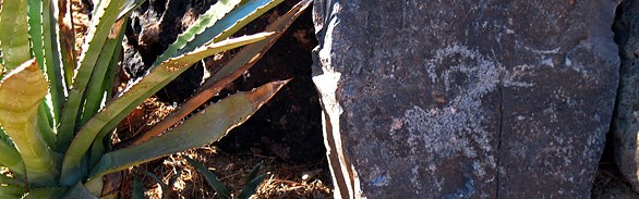
For nearly fifteen hundred years, the Hohokam people farmed and lived in central and southern Arizona and northern Mexico. They created skillfully crafted pottery and shell jewelry, which they traded for turquoise and other goods in a network that extended from Mexico to the Pacific coast. In A.D. 1450, when they abandoned the area for reasons unknown, they left behind an incredible wealth of ruins, rock art, and canals—sites and artifacts distributed over 27,000 square miles. These are the last physical clues describing a people who exhibited great cultural refinement and ingenuity.
Hohokam is derived from the Akimel O’odham word for “those who have gone” or “all used up.” The reasons for their disappearance may include limited land and water, yet their ability to manage and create those resources was impressive. The irrigation system the Hohokam created stretched for hundreds, or possibly thousands of miles, from the Salt and Gila rivers. This system transformed desert valleys into fertile agricultural centers and rich riparian corridors, providing water to tens of thousands of individuals. This network is the precursor to modern-day Arizona’s major canal system, which follows many of the original paths. Because the Hohokam had no draft animals, this feat of hydrological engineering was accomplished by hand, using only stone tools and simple survey equipment.
The great achievement of the Hohokam lay in their ability to manage the harsh desert landscape for the resources they required to eat, trade, and produce stunning pieces of shell and ceramic art. They did not simply subsist in the Salt and Gila River Valleys—they thrived on a varied diet of corn, jackbeans, tepary beans, lima beans, squash, barley, and amaranth. They grew cotton, gourds, and tobacco for textiles, art, and possibly ceremonial use. The Hohokam also made use of almost 200 species of Sonoran Desert species, encouraging the growth of cholla cactus and agave, and may even have promoted or developed new strains with distinct flavors. The lush fields and canal vegetation provided habitat for game, fish, and mollusks hunted and gathered by the Hohokam for food and trade.
Human History
The evidence of many Hohokam villages lies buried under urban development where they coincide with major cities such as Phoenix and Tucson. Opportunists brought the canals to life again to settle in the otherwise inhospitable desert. In 1868, Jack Swilling re-established canals that led to the settlement of Phoenix—a city rising from the ruins of an earlier culture, named for the mythical Egyptian bird that rose from ashes.Today, central Arizona’s major canal system makes use of the same ancient routes. Berms and irrigation wells in Phoenix’s older neighborhoods are relics of the city’s early history. A system that once brought water to thousands is now being used to help supply the modern water needs of millions.
Many of these ancient canals, while still in use, have been expanded and obscured by concrete. At the Park of Four Waters, some Hohokam canals are preserved and still visible. This site lies adjacent to The Pueblo Grande Museum and Archaeological Park just north of the Sky Harbor Airport in Phoenix. Pueblo Grande, literally “big village,” is one of about 40 platform mounds constructed in the Salt River Valley. These structures, raised on tall mounds of earth and rubble, are found approximately every three miles along the major irrigation canals. It seems likely that these villages served as management stations, where the theocratic or secular elite dictated canal construction and maintenance, as well as the allocation of water throughout the region. The residents of Pueblo Grande would have been particularly influential as the site’s strategic location lies at the headwaters of a major canal system. Villages further downstream would inevitably feel the impacts of management decisions made at this site.
As farmers and hunters the Hohokam were forced to become skillful land managers, advancing beyond farming to use fire to encourage the growth of certain herbs and grasses. The canals they built, and continuously reconstructed, were designed to do more than simply deliver water. Carefully tended stands of riparian vegetation promoted populations of waterfowl and other game animals. Channels of water up to 50 feet wide and 10 feet deep provided habitat for a number of native fish eaten by the Hohokam.
Ecological Importance
The Hohokam canals were home to several native species. They provided habitat for Colorado pikeminnow, the world’s largest minnows, which could grow as long as six feet and weigh as much as 80 pounds, and Gila Mountain razorback sucker achieving weights up to 30 pounds. Both of these spectacular fish are now federally endangered.One might expect to find shopping carts and old boots rather than native fish in the contemporary canal system. Nevertheless, native fish do live and breed in these waters, along with more prolific non-natives including catfish, bass, trout, and the white amur—a type of carp used to control algae and vegetation without the use of chemicals. Each year when the canals are cleaned, thousands of fish are relocated to urban lakes and ponds to be enjoyed by fisherman who have invested in an urban fishing license.
Numerous theories compete to explain the eventual disappearance of the Hohokam. Hard times resulting from soil salinization and improper irrigation, droughts, floods, war, and disease have all been suggested to explain why the Hohokam abandoned their villages in the mid-fifteenth century. Problems arise with each of these theories. As the Hohokam had been farming the area for more than 1,000 years, clearly they knew how to manage soil salinity. They had successfully weathered droughts and floods. Evidence suggesting war is incomplete and there currently are no known mass graves suggesting an epidemic. Some even argue that the Hohokam never actually left the Sonoran Desert. This theory maintains that after leaving their villages some Hohokam remained in central Arizona. The Akimel O’odham and Tohono O’odham are thought to be descendents of these Hohokam refugees.
The Hohokam may have left for any and all of these reasons. Whatever the cause, overpopulation likely contributed to the demise of their villages. Archaeologists estimate between 24,000 and 50,000 Hohakam people were living in the Sonoran Desert before their society collapsed. From this perspective, it seems strangely fitting that Hohokam sites continue to be discovered, and sometimes destroyed, by sprawling urban development driven by a population that struggles with water demand and the limited resources now available.
Pueblo Grande is one of the last remaining sites of its kind. It is protected by its park status and is on the National Park Service list of National Historic Landmarks.
Contributing Writers
Kim Whitley and Jeri Ledbetter.
Photo © Kim Whitley
Links
Visitation
Pueblo Grande Museum and Archaeological Park
National Park Service -- Pueblo Grande
Water Use
Preservation
Pueblo Grande – National Historic Landmark
Bibliography
- Andrews, J.P. and T.W. Bostwick 2000 Desert Farmers at the
River’s Edge: The Hohokam and Pueblo Grande Phoenix - Crown, Patricia L. and James W. Judge, eds. 1991 Chaco & Hohokam: Prehistoric Regional Systems in the American Southwest. School of American Research Press, Santa Fe.
- Doyel, David E., ed. 1987 The Hohokam Village: Site Structure and Organization. American Association for the Advancement of Science, Glenwood Springs, Co.
- Gumerman, George J., ed. 1995 Exploring the Hohokam: Prehistoric Desert Peoples of the American Southwest. University of New Mexico Press, Albuquerque.
- Hamann, Diane L. 1995 Hohokam Rock Art of Southern Arizona: A Regional Overview. In Rock Art Studies in the Americas. Edited by Jack Steinbring, pp. 77-82. Oxbow Monograph No. 45, Oxford.
- Haury, Emil W. 1976 The Hohokam: Desert Farmers and Craftsmen. University of Arizona Press, Tucson.
- Henderson, Kathy, Tobi Taylor, and Johna Hutira 1995 Layers of History: The Archaeology of Heritage Square Phoenix
- Howard, Jerry B. and Gary Huckleberry 1991 The Operation and Evolution of an Irrigation System: The East Papago Canal Study. Soil Systems Publications in Archaeology No. 18, Phoenix.
- Masse, W. Bruce 1976 The Hohokam Expressway Project: A Study of Irrigation in the Salt River Valley, Arizona. Contributions to Highway Salvage Archaeology in Arizona No. 43. Arizona State Museum, Tucson.
- Noble, David G., ed. 1991 The Hohokam: Ancient People of the Desert. School of American Research Press, Santa Fe.
- Wilcox, David R., Thomas R. McGuire and Charles Sternberg 1981 Snaketown Revisited. Arizona State Museum Archaeological Series No. 155, Tucson.