Lees Ferry
Introduction
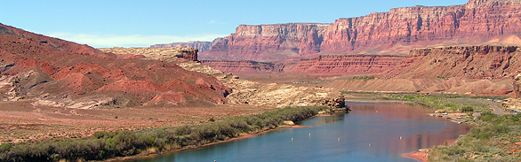
 Viewing the surroundings at Lees Ferry, the eye follows the river upstream into the mysterious red labyrinth of Glen Canyon, and downstream searches between massive, tiered cliffs, yearning to explore the wonders of Grand Canyon. Lees Ferry has been aptly described as the Grand Central Station of the Southwest. At this languorous bend, the mighty Colorado River meets the diminutive, but potent, Paria River in a multidimensional confluence of two geologic eons, two spectacular and very different canyons, the Echo and Vermillion Cliffs escarpments, three ecological biomes, several Native American and Anglo-American cultures, virulent water and conservation politics, and more than 70,000 river runners, anglers, and other visitors every year. Where the here and now meets the there and then, such a convention constitutes a point of transition, with considerable potential for conflict. Lees Ferry has plenty of both.
Geography
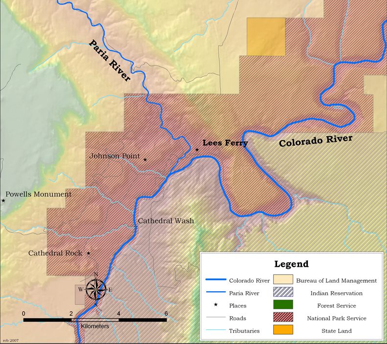
Lees Ferry lies on the Colorado River in north-central Arizona, 6 miles northeast of the Navajo Bridges of Highway 89A and Marble Canyon in Coconino County. Glen Canyon Dam, one of the largest dams in the United States, impounds the river 15-1/2 miles upstream. The Ferry, as it is colloquially known, is co-managed by Glen Canyon National Recreation Area, a National Park unit that has jurisdiction over the river and the west side of the Colorado River upstream, and Grand Canyon National Park, which manages the river downstream. In addition, the Bureau of Reclamation controls Colorado River releases from the dam, the State of Arizona claims jurisdiction over the region’s fish and wildlife, and the Navajo Nation manages the east bank of the river, primarily for grazing.
Lees Ferry is one of the few sites naturally suited for crossing the Colorado River, and is the only ferry site for nearly 450 miles of the river’s course. Otherwise bound in deep canyons, the confluence of the Colorado and Paria Rivers creates a broad floodplain, with reasonable access to the Colorado River on both of its banks. Given John Wesley Powell’s philosophy that water is the key to economic development of the West, any place where one can actually get to that water becomes important.
Geology
By daytime, even the casual visitor to Lees Ferry is struck by the barrenness of the landscape, but one is equally dazzled by the extraordinary vistas of natural color and weird geological configurations. Located on the southern Colorado Plateau and midway up the “Grand Staircase” of stacked geologic strata, the site is an open book of the earth’s history between the time of Pangaea and the rise of the dinosaurs. Turning off Highway 89A towards Lees Ferry, an almost vegetation-free desert, a massive tooth of rock called Cathedral Monument, and giant “hoodoos” (rocks on pedestals of mudstone) at the base of the Moenkopi Cliffs hint at ancient and massive scales and the peculiar nature of this area. Upstream and surrounding the Ferry itself, magnificent Mesozoic strata rise more than 3,000 feet. From the river up, these include: the Moenkopi, Shinarump Conglomerate and other Chinle (pronounced “schin-lee”) Shale members (with fossils of sharks, turtles, the earliest mammals, and much petrified wood), Kayenta, and a thick exposure of Navajo Sandstone Formations, with several small buttes of Jurassic deposits. Downstream from Lees Ferry, the Kaibab Limestone emerges from the river. The caprock for much of the southern Colorado Plateau, this is the layer on which one stands looking into Grand Canyon from the North or South Rims, 50 miles south of Lees Ferry. Thus, the Kaibab Limestone rises 5,000 feet from Lees Ferry to the North Rim.
Hydrology
Lees Ferry has one of the longest continuous flow and sediment transport records of any stream gauge in the United States. The gauge was installed in 1922, and a few previous historic flood elevations also were documented, including flows of 150,000 to 250,000 cfs (cubic feet/second) in 1921 and 1884, respectively. Prior to impoundment by Glen Canyon Dam in 1963, the Colorado River was a seasonally varying stream that sustained annual spring-early summer snowmelt floods of nearly 90,000 cfs and transported an average of 65 million tons of sand and silt past the gauge each year. Ten-year floods approached 120,000 cfs, and 100-year floods approached 200,000 cfs. Following impoundment by Glen Canyon Dam, hydropower production created daily flow fluctuations, with higher mid-summer and mid-winter flows, and lower flows in spring and fall. Water released from the dam is clear and cold. The post-dam, clearwater river quickly erodes sandbars, and its cold waters have challenged native warmwater fish as well as the safety of river runners.
Ecology
Lees Ferry lies near the margin of three of the four biomes in the Four Corners area. The Great Basin Desert to the northwest is dominated by sagebrush and other dry summer/cold wet winter shrubs. The Sonoran Desert to the south and west is a hot wet summer, cool wet winter desert, dominated by cacti, mesquite, catclaw, and other desert plant species. Upland and boreal species, like pines and Douglas fir, are derived from the Rocky Mountain biome, and occupy protected, north-facing slopes in the region. Thus, the great diversity of plant species in the Lees Ferry area is the result of floristic mixing among these three biomes.
Conservation
Dam-related changes in flood frequency, sediment transport, and water temperature have radically altered the Colorado River ecosystem. Increased water clarity has increased aquatic algal and invertebrate production between the dam and the Paria River. The now-stabilized shorelines allow extensive and productive riparian vegetation to encroach down to the post-dam water line. These changes have increased food and habitat availability to waterbirds and other vertebrate populations. However much of the vegetation is non-native, dominated by saltcedar (tamarisk). Also, the introduction of 20 non-native fish species has led to the loss of four of the eight native fish species in the river. The Ferry’s long-term flow records are used to help restore the Colorado River ecosystem downstream from the dam.
From 2000-2005, the Grand Canyon Wildlands Council, working with Phillips Consulting LLC of Flagstaff, the National Park Service, and the Arizona Water Protection Fund, mechanically removed non-native saltcedar (tamarisk) from 10 acres of the riverbank just downstream from Lees Ferry, and planted and grew native Fremont cottonwood, Goodding’s willow, and other native vegetation. This stand replacement was highly successful, and that portion of the Colorado River is now strongly dominated by native vegetation, species that may provide a seed source for further expansion of native plants downstream.
Human History
Evidence of Pueblan Kayenta Anasazi has been found in the Lees Ferry area, indicating that it was visited more than 1,000 years ago by members of the agriculturally-inclined culture. In contemporary times, it was disputed territory between the Paiute and Navajo Tribes, resulting in several conflicts.
The Escalante-Dominguez expedition passed by Lees Ferry on their return from Utah Lake, Utah, on October 26, 1776. Several of the Spanish explorers tried to swim across the Colorado River with their clothes on their backs, losing their clothes in the effort. They then ascended the steep slopes of the lower Paria River and continued on their way back to Santa Fe, New Mexico. It was not visited again by Anglo-Europeans until 1858, when Mormon explorer Jacob Hamblin arrived with his Paiute guide, Naraguts.
Excommunicated Mormon John Doyle Lee settled there in 1871 with his seventeenth wife, Emma, who named it Lonely Dell, a name now reserved for their ranch on the lower Paria River. Beginning in 1872, Lee used two boats abandoned by John Wesley Powell to begin ferry service in 1872. Lee was attempting to avoid prosecution over a massacre of pioneers he helped lead, and for which he was executed in 1877. After Lee’s death, Emma ran the Ferry until 1879, and thereafter it was operated by Warren Johnson and his sons until 1896, then by James S. Emett until 1909, briefly by the Grand Canyon Cattle Company, and lastly, by three of Warren Johnson’s sons for Coconino County until 1928. The ferry was a dangerous operation, and an accident that year killed three men. As Navajo Bridge was under construction, and completed in 1929, the Ferry was abandoned after that accident.
Life at Lees Ferry has been well chronicled and was filled with unusual events. Floods, drought, intense desert heat, and poor Paria River water quality plagued the settlers there. Entrepreneur Charles Spencer sought to extract gold dust from the Chinle Shale, building a steamboat in 1914 to deliver coal from southern Utah to run his filtration process. Although his efforts were fruitless, his abandoned equipment has been registered as historic by the National Park Service. A small community of homesteaders grew up at Lees Ferry, raising cattle and growing melons, alfalfa, and fruit trees. The settlers built a school and after 1922, the U.S. Geological Survey maintained facilities for a streamflow gauge operator. History officially ended at Lees Ferry when the federal government took over the site in 1956, forcing out the homesteaders and developing the land for recreational purposes; however, Emma Lee’s Lonely Dell Ranch remained in private hands until 1974, when it was purchased by the government.
Managing the Colorado River: “More Politics than Water”
The Colorado River is the primary surface-water source for most of the Southwest. The Colorado River Compact of 1922 established Lees Ferry as the boundary between the Upper and Lower Colorado River basins. An over-estimated 8.23 million acre-feet of water was to pass that point each year to guarantee water for Nevada, Arizona, and California. The Compact is one of the key elements of the voluminous body of laws known as the “Law of the River”, which allocates the use of the river in this arid region. The Compact set the stage for the Bureau of Reclamation to regulate the flow of the river in the Lower Basin, and the Colorado River Storage and Power Act did the same for the Upper Basin states of Wyoming, Colorado, Utah, and New Mexico in 1956. Because the river is over-allocated, these laws have generated more conflict than agreement.
After much controversy about dam-related degradation of natural and cultural resources in Grand Canyon, and in accord with the Grand Canyon Protection Act of 1992, an Environmental Impact Statement (1995) and Record of Decision (1996) directed the Bureau of Reclamation to moderate releases from Glen Canyon Dam to minimize damage and enhance natural resource conditions downstream. Today, a 27-stakeholder Federal Advisory Committee, called the Glen Canyon Dam Adaptive Management Work Group, evaluates the impacts of Glen Canyon Dam on the Colorado River ecosystem, and advises the Secretary of the Interior on how to mitigate impacts and enhance resource conditions. These meetings are open to the public and provide much insight into how complex water management has become in the Southwest.
Lees Ferry Today
Lees Ferry is now a very actively visited and used recreation area, with excellent facilities and a good campground. The trophy trout fishery that sprang up in the post-dam, cold, clear river attracts anglers from all over the world. Those same clear-water conditions favor waterfowl use from mid-November through February, and Lees Ferry is one of the best places in the state to observe these birds. More than 40,000 visitors take the half-day boat ride from the dam down to Lees Ferry each year, and many visitors motor boats upstream to enjoy the last remaining flowing portion of Glen Canyon. Between April and November, with minor winter use, more than 22,000 people per year arrive at Lees Ferry to launch on the trip of a lifetime through Grand Canyon. A permit is required from Grand Canyon National Park for all downstream river trips, and 17 companies conduct guided trips through Grand Canyon. Despite all this use, the Ferry remains a wonderfully diverse and historic place to visit, with excellent accommodations at Marble Canyon, Vermilion Cliffs, and Cliff Dwellers Lodges.
Contributing Writers
Larry Stevens and Jeri Ledbetter.
Photo © Vicky Butherus
Links
Visitation
Lees Ferry Fly Fishing
Glen Canyon NRA
Water Resources
Historical Records, USGSReal-Time data, USGS
Conservation
Grand Canyon Wildlands CouncilGrand Canyon Monitoring and Research Center
Human History
Grand Canyon Monitoring and Research Center, http://www.gcmrc.gov/about/programs/cultural/Bibliography
- Brooks, J. 1978. Emma Lee. Utah State University Press, Logan.
- Hughes, J.D. 1878. In the house of stone and light. Grand Canyon Association, Grand Canyon.
- Phoenix, D.A. 1963. Geology of the Lees Ferry area, Coconino County, Arizona. U.S. Geological Survey Bulletin 1137.
- Reilly, P.T. (edited by R.H. Webb). 1999. Lee’s Ferry, from Mormon crossing to National Park. Utah State University Press, Logan.
- Rusho, W.L. and C.G. Crampton. 1992. Lee’s Ferry: desert river crossing. Cricket Productions, Salt Lake City.
- Stevens et al. 1997a
- Stevens, L.E., J.P. Shannon and D.W. Blinn. 1997b. Benthic ecology of the Colorado River in Grand Canyon: dam and geomorphic influences. Regulated Rivers: Research & Management 13:129-149.
- Topping, D.J. J.. Schmidt, and LE. Vierra, Jr. 2003. Computation and analysis of the instantaneous-discharge record for the Colorado River at Lees Ferry, Arizona—May 8, 1921, through September 30, 2000. U.S. Geological Survey Professional Paper 1677.
- Warner, T.J 1995. The Domínguez-Escalante journal: their expedition through Colorado, Utah, Arizona, and New Mexico in 1776. Utah State University Press, Logan.