
Thunder Springs and Thunder River, Grand Canyon National Park, Arizona
Introduction
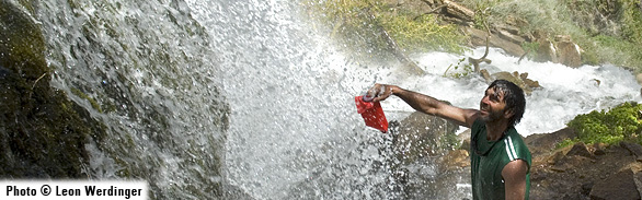
 In any landscape other than Grand Canyon, Thunder River would be a national park in its own right. This cold gushet spring leaps from a deep cave and plunges down a massive redwall limestone cliff onto the hot, harsh slopes of Grand Canyon. Thunder Springs’ ermine cascade is an oasis in descent, supporting a large stand of Fremont cottonwood trees just below its source, lush walls of ferns, and rich beds of crimson monkeyflower – a flow supporting a verdant slash through the Sonoran Desert on its collision course with Tapeats Creek. One of the few rivers that is a tributary of a creek, Thunder River drops around 1,200 feet over its journey of only 1/2 mile. Renowned for its spectacular scenic value and rich biodiversity, this spring was ranked as one of the top ten destinations by Backpacker Magazine.
Thunder Springs emerge from a deep cave system off the North Rim of Grand Canyon at an elevation of 3,360 feet above sea level. The landscape of the region provides evidence of one of the most massive slope failure events in the Southwest. Several hundred thousand years ago more than five miles of the North Rim catastrophically collapsed into Grand Canyon, temporarily damming the Colorado River and forcing it to cut a new course.
Ecological Importance
Thunder River is a moderately large spring for the southern Colorado Plateau, covering approximately 2.5 acres. The second largest spring on the North Rim of Grand Canyon—the largest being Tapeats—its pristine water emerges at about 12 degrees C.
With a south-southeast facing aspect, it captures a large amount of the potential solar radiation (sunlight unobstructed by cliffs), including: 91 percent of the available winter sunlight, 85.7 percent of that in spring, 81.3 percent of summer sunlight, and 90.3 percent of the autumn light.
Thunder River contains five geomorphic microenvironments that support 36 plant species, 29 of which are native. The least vegetation occurs, of course, in caves and where cascading (madicolous) flows madly dash over waterfalls and onto cliff faces and boulders—only mosses can persist in such settings. Wet and dry backwalls support crimson monkeyflower, maidenhair fern, and other wetland and riparian species, while the steep stream channel supports profuse riparian true willows, seepwillows, and other shrubs. The spring’s colluvial slopes are densely covered by a large, robust stand of Fremont cottonwood, surrounded by an understory of white sumac—a species of management interest to Grand Canyon National Park.
Also of particular interest are landsnails, for which Thunder River is renowned. A veritable hotspot, the springs provide habitat for a dozen landsnail species, as well as several boreal species that reach the lower limits of their elevational ranges. The other fauna of Thunder River have not been intensively analyzed, but the springs support large populations of stoneflies and caddisflies.
Conservation
Lying wholly within Grand Canyon National Park, one would expect Thunder River to be free from most human threats. However the aquifer upon which it depends, like aquifers on the Canyon’s South Rim, is not fully protected. Future groundwater withdrawal will threaten flows of Thunder River and other Redwall aquifers in the Park. More immediate threats involve the possibility of human-caused fire— not a historical form of disturbance but one more likely due to heavy visitation in the area. One match could destroy this truly unique, isolated stand of Fremont cottonwood trees—trees that are easily killed by wildfire—and a habitat that is highly unlikely to recover.
Contributing Writers
Larry Stevens, John Rihs, and Steve Rice.
Photo © Leon Werdinger
Links
Visitation:
http://www.nps.gov/grca/planyourvisit/backcountry-permit.htmhttp://www.terragalleria.com/parks/np.grand-canyon.7.html
Water Resources:
http://web.umr.edu/~rogersda/cp_megalandslides/thunder_river.htmBiological information:
http://jan.ucc.nau.edu/~pju/Kaufmanetal.2002-QRes.pdfBibliography
- Rogers, J.D. and M.R. Pyles. 1980. Evidence of catastrophic erosional events in the Grand Canyon. Proceedings of the 2nd Conference on Scientific Research in National Parks 5:392-454.
- Spamer, E.E. and A.E. Bogan. 1993. Mollusca of the Grand Canyon and vicinity, Arizona: new and revised data on diversity and distributions, with notes on Pleistocene-Holocene mollusks of the Grand Canyon. Proceedings of the Academy of Natural Sciences of Philadelphia 144:21-68.
- Springer, A.E., L.E. Stevens, and R. Harms. 2006. Inventory and classification of selected National Park Service springs on the Colorado Plateau: NPS Cooperative Agreement Number CA 1200-99-009. National Park Service, Flagstaff.
- Stevens, L.E., R.J. Johnson, B. Perla, and K.J. Burke. 2002. A hydrological and biological inventory of springs, seeps and ponds of the Arizona Strip, final report. Arizona Water Protection Fund, Phoenix.