Upper Verde River
Introduction
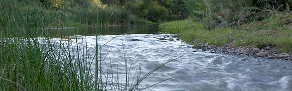
As Arizona’s only Wild and Scenic River, the Verde’s mood varies from gentle meanders to white-water rapids as it winds through mountains, upland plains and desert valleys of central Arizona. As much of it flows through federally and state managed land, the Verde provides unique recreational opportunities, including hiking, bird-watching, fishing, and kayaking. Rich in natural beauty, the upper Verde and its tributaries support extensive woody riparian and wetland vegetation that provides critical habitat for native fish, birds and mammals, including several federally endangered and threatened species.
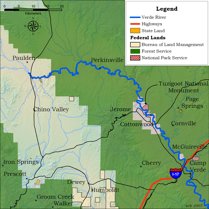
The upper Verde River originates in Yavapai County, Arizona, east of Paulden from a series of springs in the remote and rugged upper canyons below Sullivan Lake. Most of the first 22 miles of the Verde’s base flow is dependent on these springs, fed by interconnected aquifers in the Big Chino basin. Below Perkinsville the Verde is joined by additional springs and the ephemeral tributaries of Granite Creek, Big Chino Wash, Hell Canyon, and Sycamore Canyon. Perennial tributaries—Oak Creek, Wet Beaver Creek, and West Clear Creek—as well as ephemeral washes, feed the middle Verde River. Below a 40-mile stretch designated as Wild and Scenic, the Horseshoe and Bartlett dams form two major reservoirs before the lower Verde joins the Salt River south of Fountain Hills.
The Upper Verde River lies within the Transition Zone of central Arizona, between the Colorado Plateau to the north and the Basin and Range zone to the south. The watershed extends from the Coconino Plateau in the north to the Salt River in the south, and from the Juniper and Santa Maria Mountains in the west to the Mogollon Rim in the east. The 140-mile Verde drains 6,615 square miles of Arizona, and is prone to flooding. Until the 1890s, the riparian zone was, in places, over a mile wide, creating a series of marshes and sloughs that provided habitat for a variety of plants and animals. A severe flood event in 1983 incised the river channel. Peck’s Lake and Tavasci Marsh, near Cottonwood, are abandoned meanders of the ancestral Verde River.
Ecological Importance
The Verde supports extensive woody riparian and wetland vegetation, and provides critical habitat for a diversity of native aquatic and riparian-dependent species. Historically the Verde River supported 16 native fish species; only 10 remain. These include the federally endangered razorback sucker and Colorado pikeminnow, as well as the threatened spikedace. Three sensitive riparian herpetofauna species survive in the watershed: the northern Mexican gartersnake, the narrow headed gartersnake, and the lowland leopard frog. The Verde River supports a high density of breeding birds; over 200 resident and neo-tropical migratory bird species have been recorded. Species such as the federally endangered southwestern willow flycatcher and the yellow-billed cuckoo depend on the river’s woody riparian forests of cottonwood, willow and ash for their tenuous survival. The Verde supports the largest number of bald eagle breeding areas of any river in the state, and is one of only three rivers in Arizona with populations of river otter.
Human History
The Verde River is significant for its history, cultural and biological values, recreational opportunities, and scenery. In the Verde Valley, cliff ruins and pueblos at Tuzigoot and Montezuma Castle National Monuments provide evidence of the Sinagua culture dating from A.D. 1000. Earlier cultures may have lived in the valley as much as 10,000 years ago. As in other parts of the Southwest, an extensive drought in the late 1200s probably contributed to abandonment of these sites. Spanish missionaries visited the area in the sixteenth and eighteenth centuries, but did not attempt to settle there. European settlement began in the 1860s when gold was discovered near Prescott in 1863.
Conservation
Since the late 1800s, human activities have affected the river’s ecosystems through introduction of non-native aquatic and vegetative species, timber harvest, grazing, fire suppression, mining, agriculture, development, groundwater pumping, and surface diversions. Surface water is heavily diverted for agricultural irrigation. All domestic, municipal, and industrial water comes from groundwater pumping in the watersheds; additional irrigation water also comes from groundwater in the Big and Little Chino watersheds, above the river’s headwater springs.
In 1999, Yavapai County was the fastest growing rural county in the United States. Its population—132,000 in the year 2000—is expected to more than double over the next 50 years. Continued depletion of aquifers through groundwater pumping to support this growth threatens the flow of the springs, and therefore the flow of the upper Verde.
While water quality of the river is generally good, past mining operations have resulted in high levels of sodium, turbidity, boron, mercury, iron, ammonium, and selenium in some areas.
Twenty-five non-native fish, bullfrogs and crayfish displace, compete with, or prey on native aquatic and riparian species, contributing to declines and loss of native species. However, sport fishing in the Verde River, particularly in the Camp Verde area, is a popular pastime.
Near the headwaters, Arizona Game and Fish Department manages the Upper Verde River Wildlife Area for riparian habitat and native fish diversity. Tavasci Marsh has been designated as an Important Bird Area by the Audubon Society of Northern Arizona. The National Park Service manages several national monuments within the watershed, including Tuzigoot and Montezuma Castle, for their pre-historic significance. The Verde River Greenway, a 6-mile stretch of cottonwood-willow gallery forest near Cottonwood, is managed by the State Park system as a natural area. The Fort Verde State Historic Site preserves the first military installation in the Verde Valley. The Wild and Scenic River segments begin at Beasley Flat and include about 40 miles of river, managed for its free-flowing character and wild and scenic values.
Contributing writers
Brenda Smith, U.S. Fish and Wildlife Service, and Jeri Ledbetter.
Photo © Jeri Ledbetter
Links
Visitation
Tuzigoot National Monument
National Forest Service
Dead Horse Ranch State Park
Water Resources
USGS Stream flow and water quality data
Verde River Basin Partnership
Biological Information
Riparian inventories U.S. Fish and Wildlife Service
Threatened and endangered species in Arizona
Historical Information
Sharlot Hall Museum
Special Collections at the Northern Arizona University Library
Arizona Historical collections at Arizona State University.
Conservation
Verde Watershed Association
Friends of the Verde River Greenway
National Forest Service
Arizona State Parks
Verde Wild and Scenic Comprehensive River Management Plan
Bibliography
- Allen, Stephenson, & Associates. 2001. Hydrogeology study, The ranch at Del Rio Springs, town of Chino Valley, Arizona, October 25, 2001.
- Anderson, C.A., and Blacet, P.M. 1972. Precambrian geology of the northern Bradshaw Mountains: U.S. Geological Survey Bulletin 1336, p. 176–177.
- Anderson, C.A., and Creasey, S.C. 1958. Geology and ore deposits of the Jerome area, Yavapai County, Arizona: U.S. Geological Survey Professional Paper 308, 185 p.
- Anning, D.W. 2004. Uncertainty in low-flow data from three streamflow-gaging stations on the upper Verde River, Arizona, in Sehlke, Gerald, Hayes, D.F., and Stevens, D.K., eds., Critical transitions in water and environmental resources management: World Water and Environmental Resources Congress 2004, June 27–July 1, 2004, Salt Lake City, Utah, electronic book, p. 1–8.
- Arizona Department of Water Resources. 1991. Management plan for the second management period 1990–2000, Prescott Active Management Area: Arizona Department of Water Resources, 216 p.
- Arizona Department of Water Resources. 2000. Verde River watershed study: Arizona Department of Water Resources, Phoenix, Arizona, v.p.
- Arizona Department of Water Resources. 2003. Prescott Active Management Area 2002–2003—Hydrologic monitoring report: Phoenix, Arizona Department of Water Resources, 21 p.
- Barnett, L.O., and R.H. Hawkins. 2002. Reconnaissance watershed analysis on the Upper and Middle Verde watershed. Arizona Rural Watershed Initiative Report. Agreement No. 23934 between the Arizona Department of Water Resources and the University of Arizona, School of Renewable Natural Resources.
- Bills, D.J., Flynn, M.E., and Monroe, S.A. In press. Hydrogeology of the Coconino Plateau and adjacent areas, Coconino and Yavapai Counties, Arizona: U.S. Geological Survey Scientific Investigations Report 2005–5222.
- Blakey, R.C.. 1990. Stratigraphy and geologic history of Pennsylvanian and Permian rocks, Mogollon Rim region, central Arizona and vicinity: Geological Society of America Bulletin, v. 102, no. 9, p. 1189–1217.
- Blasch, K.W., Hoffmann, J.P., Graser, L.F., Bryson, J.R., and Flint, A.L. 2006. Hydrogeology of the upper and middle Verde River watersheds, central Arizona: U.S. Geological Survey Scientific Investigations Report 2005–5198, 101 p., 3 plates.
- Corkhill, E.F., and Mason, D.A. 1995. Hydrogeology and simulation of ground water flow, Prescott Active Management Area, Yavapai County, Arizona: Arizona Department of Water Resources Modeling Report, no. 9, 143 p.
- DeWitt, Ed, Langenheim, V.E., Force, Eric, Vance, Kelly, and Lindberg, P.A. In press. Geologic map of the Prescott National Forest and headwaters of the Verde River, Yavapai and Coconino Counties, Arizona—With a digital database by Doug Hirschberg, Guy Pinhassi, and Nancy Shock: U.S. Geological Survey Miscellaneous Investigations Map.
- DeWitt, Ed, Langenheim, V.E., and Wirt, L. 2005. Geologic framework of aquifer units and ground-water flow paths, Verde River headwaters, north-central Arizona: U.S. Geological Survey Open File Report 2004–1411-B, p. 24.
- Ewing, D.B., J.C. Osterberg, and W.R. Talbot. 1994. Big Chino groundwater study: Bureau of Reclamation Technical Report, 3 sections.
- Fewkes, J. W. 1912. Antiquities of the upper Verde River and Walnut Creek valleys of Arizona. 28th annual report of the Bureau of American Ethnology
- Foust, R.D., Mohapatra, P., Comton-O’Brien, A.M., and Reifel, J.. 2004. Groundwater arsenic in the Verde Valley in central Arizona, USA: Applied Geochemistry, v. 19, no. 2, p. 251–255.
- Hart, R.J., Ward, J.J., Bills, D.J., and Flynn, M.E.. 2002. Generalized hydrogeology and ground-water budget for the C aquifer, Little Colorado River Basin and parts of the Verde and Salt River Basins, Arizona and New Mexico: U.S. Geological Survey Water-Resources Investigations Report 02–4026, 47 p.
- Haskett, Bert 1935. Early History of the cattle industry in Arizona. Arizona Historical Review VI (4):3-42.
- Henson, P. 1965. Founding a Wilderness Capital: Prescott. Northland Press, Flagstaff. 261 pp.
- Jenkins, O.P. 1923. Verde River lake beds near Clarkdale, Arizona: American Journal of Science, 5th ser., v. 5, no. 25, p. 65–81.
- Knauth, L. P., and M. Greenbie. 1997. Stable isotope investigation of ground-water-surface-water interactions in the Verde River headwaters area: Arizona State University Department of Geology report in fulfillment of Arizona Water Protection Fund Grant #95-001, administered by Arizona Department of Water Resources, 28 p.
- Krieger, M.H. 1965. Geology of the Prescott and Paulden quadrangles, Arizona. U.S. Geological Survey Professional Paper 467, 127 p.
- Langenheim, V.E., Hoffmann, J.P., Blasch, K.W., DeWitt, Ed, and Wirt, L. 2002. Preliminary report on geophysical data in Yavapai County, Arizona: U.S. Geological Survey Open-File Report 02–352, 28 p.
- Langenheim, V.E., DeWitt, Ed, and Wirt, Laurie, 2005, Preliminary geophysical framework of the upper and middle Verde River watershed, Yavapai County, Arizona: U.S. Geological Survey Open-File Report 2005–1154, 43 p.
- Lehner, R.E. 1958. Geology of the Clarkdale quadrangle, Arizona: U.S. Geological Survey Bulletin 1021-N, p. 511–592.
- Levings, G.W. 1980. Water resources in the Sedona area Yavapai and Coconino Counties, Arizona: Arizona Water Commission Bulletin 11, 37 p.
- Levings, G.W., and L.J. Mann. 1980. Maps showing groundwater conditions in the upper Verde River area, Yavapai and Coconino Counties, Arizona-1978: U.S. Geological Survey Water-Resources Investigations, Open-File Report 80-726.
- Matlock, W. G., P. R. Davis, and R. L. Roth. 1973. Groundwater in Little Chino Valley, Arizona: University of Arizona Agricultural Experiment Station, Technical Bulletin 201, 19 p.
- Nelson, K. 2002. Application of the Prescott Active Management Area groundwater flow model, planning scenario 1999–2025, Modeling Report No. 12: Arizona Department of Water Resources Hydrology Division, September 2002, 49 p.
- Ostenaa, D.A., U.S. Schimschal, C.E. King, J.W. Wright, R.B. Furgerson, H.C. Harrel, and R.H. Throner. 1993. Big Chino Valley groundwater study: geologic framework investigations. Bureau of Reclamation, Denver Office, 31 p.
- Owen-Joyce, S.J. 1984. Hydrology of a stream-aquifer system in the Camp Verde area, Yavapai County, Arizona: Arizona Department of Water Resources Bulletin 3, 60 p.
- Owen-Joyce, S.J., and C.K. Bell. 1983. Appraisal of water resources in the Upper Verde River area, Yavapai and Coconino Counties, Arizona: Arizona Department of Water Resources Bulletin 2, 219 p.
- Parker, J.T.C., and Flynn, M.E. 2000. Investigation of the geology and hydrology of the Mogollon Highlands of central Arizona—A project of the Arizona Rural Watershed Initiative: U.S. Geological Survey Fact Sheet 159–00, 4 p.
- Schwab, K.J. 1995. Maps showing groundwater conditions in the Big Chino sub-basin of the Verde River Basin, Coconino and Yavapai Counties, Arizona—1992: Arizona Department of Water Resources Hydrologic Map Series Report no. 28.
- Shaw, H. G. 2006. Wood plenty, grass good, water none: Vegetation changes in Arizona’s upper Verde River watershed from 1850 to 1997. Gen. Tech. Rep. RMRSGTR- 177. Fort Collins, CO: U.S. Department of Agriculture, Forest Service, Rocky Mountain Research Station. 50 p.
- Southwest Ground-water Consultants, Inc. 2005. Big Chino Ranch hydrology study, City of Prescott Public Works Department, 138 p.
- Twenter, F.R., and Metzger D.G. 1963. Geology and ground water in Verde Valley—The Mogollon Rim region Arizona, Geological Survey Bulletin 1177, 132 p.
- Wallace, B. L. and R. L. Laney. 1976. Maps showing groundwater conditions in the lower Big Chino Valley and Williamson Valley areas, Yavapai and Coconino Counties, Arizona - 1975-76: U.S. Geological Survey Water Resources Investigations 76-78 Open File Report, 2 maps.
- Water Resources Associates. 1990. Hydrogeology investigation of Big Chino Valley, Yavapai County, Arizona: Phase II, consultants report for City of Prescott, City Attorney’s Office, Prescott, Arizona, February 5, 1990, 3 vols.
- Wendt, G.E., Winkelaar, P., Wiesner, C.W., Bither, R.A., Whitney, B.A., and Larson, K.N. 1976. Soil survey of Yavapai County, Arizona, western part, United States Department of Agriculture Soil Conservation Service and Forest Service, 121 p.
- Western Resource Advocates. 2003. Smart water—A comparative study of urban water use across the Southwest: Boulder, Colorado, Western Resource Advocates, 178 p.
- Wirt, L. 1993. Isotopic content and water chemistry of ground water that supplies springs in the Verde headwaters, Yavapai County, Arizona: Proceedings of the Arizona Hydrological Society Annual Symposium, 4 p. (abstract)
- Wirt, L. 1992. Use of stable isotopes and water chemistry to determine movement of water in the upper Verde River basin, Yavapai County, AZ. Sixth Annual Meeting of the Arizona Riparian Council, Cottonwood, Arizona, 2 p. (abstract)
- Wirt, L. and H.W. Hjalmarson. 2000. Sources of springs supplying base flow to the Verde River headwaters, Yavapai County, Arizona. U.S. Geological Survey Open File Report 99-0378.
- Woessner, W.W. 1998. Evaluation of two groundwater models of the Prescott Active Management Area: ADWR Model (1995) and Southwest Ground-water Consultants, Inc. Model (1998): Arizona Department of Water Resources, 29 p.